Accountability, Transparency, Coordination of Actions: 4 Tools Available to the Public and to Sahel Alliance Members
The Sahel Alliance developed tools designed to provide transparent information to the public and to facilitate coordination efforts between members. These tools offer a global view of the development initiatives implemented by members in the Sahel. In this article, we present these key tools and how to access them.
Public Mapping
The public interactive map provides an overview (as exhaustive as possible) of the territorial coverage of the projects supported by the Sahel Alliance members. Each point on the map corresponds to a location where a Sahel Alliance labelled project is being implemented. Users can filter projects by sector, country and/or member organisation, and access detailed information on each project.
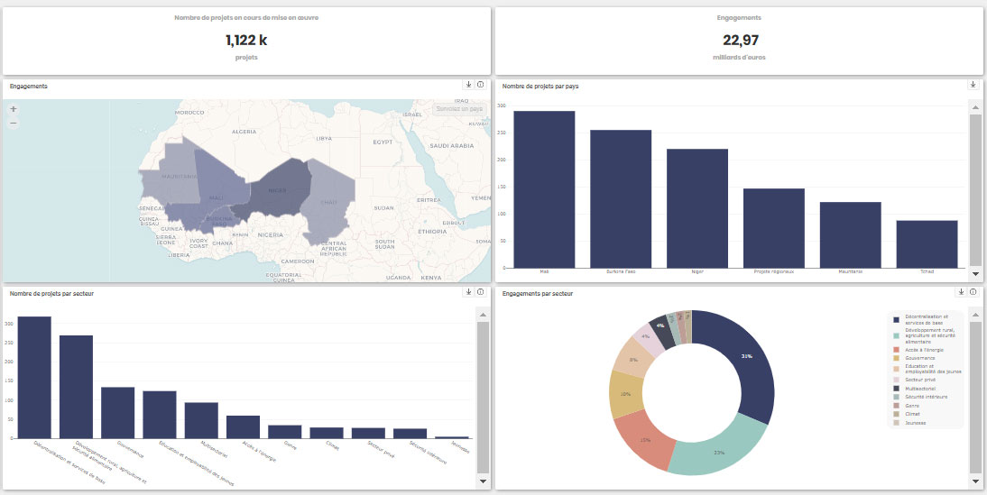
Public Data Portal
The public data portal presents the public data (updated in 2022) of Sahel Alliance labelled projects. This tool provides dynamic data visualisation using maps and graphs. The data can be exported in Excel or PNG formats, for more in-depth analysis.
https://opendata.alliance-sahel.org/
Internal Database
Sahel Alliance members have access to an internal online database containing detailed project data, updated in 2023 based on data available on 31/12/2022. This database can be used to launch and manage the collection and aggregation of results according to needs. In particular, users have access to the following data: Alliance Sahel portfolio figures, results per project and project funding data. Data can be filtered by country, sector and/or member organisation. In addition, this database offers graphs and visualisations for a better understanding of the data. Data can be exported in Excel and graphics in PNG.
In the near future, the internal database will be replaced by access for Sahel Alliance members only on the public data portal (see above). The data currently available in the internal database will also be available in the internal access, except for the private interactive map.
People working in member organisations of the Sahel Alliance can contact the Sahel Alliance’s Coordination Unit to request a login and password.
Integrated Territorial Approach (ITA) Database
Designed for members, the Integrated Territorial Approach (ITA) database is a geographic information system for decision support in the design and implementation of projects in priority fragile areas of the Sahel. It enables geolocalised on activities financed by members in these areas to be tracked and centralised. It also provides contextual data for a better understanding of the situation and needs. The data, which will be updated in 2023, can be viewed on maps, which helps with planning and decision-making.
Each member organisation of the Sahel Alliance appoints a focal point responsible for approving the access requests. Anyone wishing to obtain access can contact the Sahel Alliance’s Coordination Unit to identify the focal point within their organisation.